Research Article: 2022 Vol: 25 Issue: 3S
Road network information system (RNIS) of the roads within the university of Nigeria Enugu campus
Nwaka Okwuchukwu C, University of Nigeria
Chukwu Chinyere P, University of Silesia in Katowice
Ezugwu Chukwuma V, University of Nigeria
Citation Information: Nwaka Okwuchukwu C., Chukwu Chinyere P., & Ezugwu Chukwuma V. (2021). Road network information system (RNIS) of the roads within the university of Nigeria Enugu campus. Journal of Management Information and Decision Sciences, 25(S3), 1-11.
Abstract
Road network is considered to be one of the keys to the effective development of any region. Economic growth and development require the support of an effective and efficient transport system enabled by the road network. Given the significance of spatial data in planning, management and utilization of a road network in any society, the general purpose of this study is to produce a composite map and database that would serve as an archive for the road network within the University of Nigeria, Enugu Campus. In other to achieve this, primary and secondary data were acquired through direct field observations using Automatic level, attribute data of the existing roads from Physical Planning Unit of the campus and Geo-referenced Satellite Imagery of the study area. Geographic Information Systems (GIS) technique and AutoCAD land development software was used to process the acquired data. The processed data was integrated in QGIS (an open source application) environment and a database of the road network was designed and developed using PostgreSQL/PostGIS software. This provides an avenue for spatial querying of the various attributes of the roads. Quantum GIS software was used in this project because it is open source software that provides an avenue for spatial querying of the various attributes of the roads. This study also provides a detailed description, and classifications of the road networks, the functional classification includes: Road Name, Road Class (Major and Minor), Road Geometry (Width, Length, Profile Diagram). The results of this study include: A Map of the road network within the campus, Map of profile diagrams of the un-tarred roads and Database of the road network. This work is a pilot project, which can be carried out on a larger scale and other attributes like the drainage system, vehicular movement, maintenance due date, road construction date, etc. may be included among other things.
Keywords
Road network; GIS; Database; Open Source; Hyperlink.
Introduction
Road networks are indispensable in any society. Omunguye (2004), defined a road network is an intersection of various roads: expressways, major roads, minor roads, streets, lanes. The interconnectivity property of road network makes for transportation ease. According to Irfan (2005), Road Networks are an important part of our everyday movement from place to place and analysis of these networks improves the movement of people, goods, services and flow of resources.
Ndiwari (2014), further explained that as long as the world will continue to exist, roads are indispensable for commuting in our daily life; therefore the simple act of migrating from one place to another is absolutely essential. The ease of transportation is a major determinant of civilization and rapid urbanization, each settlement pattern is affected by transportation and a change in it will definitely have an impact on the ultimate sustainability and viability of the built Environment.
Mapped data analyses for decision making and solution findings has become an important part of planning of which road network analyses is also a major constituent. Amina & Ajie (2014), opined that map are needed for nearly every aspect of government policy and for private sector activities including Environmental Management, Population control, utilities, property development and land registration, social and health facilities establishment, and transportation.
Updating the database of road networks at specific intervals are essential elements to many Geographic Information System (GIS) applications such as navigation, urban planning, etc. The development of advanced methods for the extraction of road network and detection of road changes based on satellite imagery may provide an efficient solution to this problem.
Literature Review
Many scientific works are devoted to the study of Road Network using Geographic information system techniques, some of this research are described below:
In their Study Amina et al. (2014) developed a road network map of Port Harcourt city (Nigeria) using GIS technique. Direct field observations and satellite imagery was used as the major data source and GIS technique was used to analyze the road networks within the study area. The result of the study shows that some of the road network needed urgent attention. It also gave the permissible number of vehicles that are expected to ply each identified route. Kayondo-Ndandiko (2011) also developed an operational framework within which the use of geographic information technologies can be adopted and implemented as a decision support tools in road infrastructure maintenance in Uganda. She identified the gaps and limitations in the use of and access to Geographical Information Technologies (GITs) for Road Infrastructure Maintenance (RIM) and defines an algorithmic framework to emphasize on the importance of Geographical Information Technologies as a decision support tool in Road Maintenance.
Furthermore, Idhoko et al. (2015) in their work developed a Geographic information system Road Network Database for Emergency response in Oyo Town (Nigeria) using the following GIS methods; database design, spatial and attribute data acquisition, database creation and spatial query & analysis. The study showed that the road network can be queried for alternative routes in case of emergency and access to the nearest facility of interest. (Acquah et al., 2017) highlighted the need to implement GIS as a decision support system in road maintenance in Ghana using the roads in Kumasi Metropolis as a case study, geodatabase of road in GIS environment and visual road condition database in SQL database engine were the two application modules that were applied. The network was prioritized using multi-criteria decision analysis. Decision makers can therefore plan and prioritize the road maintenance needs in more conventional way thereby utilizing the allocated budget efficiently and effectively (Abah, 2016).
In Addition, Idhoko et al. (2016) also analyzed the road network of Yenagoa, Bayelsa State using GIS. Basic generic question on accessibility of one location from another was answered. Survey was carried out to acquire attribute data through the use of oral questionnaires and personal observation, satellite imagery and street guide map was also used as the base map. The geospatial datasets were georeferenced and linked with attribute database using the ArcGIS 10.2 software. Analysis such as: spatial road search; the shortest route between two known points was employed in assessing the road quality in Jos City (Nigeria) using GIS technique, considers its attributes as regards the road width, road type, road lane, length, road thickness, road drainage type, road covered by pedestrians and the general surface condition of the roads. The study concludes that expressway and the arterial roads available in the study area are not sufficient for the commercial nerve Centre of a state such as Jos City.
Most of the reviewed literatures utilized ArcGIS; a commercial software as the key visualization software, in this study however, we demonstrated that a freely available open source application could be used. Also, other database on road networks included several attributes of the object of study but none showed the longitudinal profile of some of the roads which are not tarred. This we believe is very important as it is a strict requirement for road construction planning and execution.
Methodology
Study Area
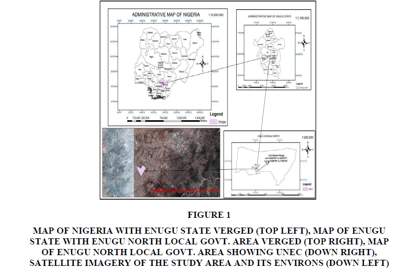
University of Nigeria, Enugu Campus is the study area. The campus is located inside Enugu town, the capital city of Enugu State, one of the states in the eastern part of Nigeria. Enugu town consist of Enugu North, Enugu South and Enugu East Local Govt. Area. The campus is located specifically in Enugu North Local Govt. Area. The campus is contained within latitude 6024’58’’N to 6025’51’’N and longitude 7029’50’’E to 7030’43’’E with an area of approximately 200 Hectares (Figure 1).
Figure 1: Map Of Nigeria With Enugu State Verged (Top Left), Map Of Enugu State With Enugu North local govt. Area Verged (Top Right), Map Of Enugu North Local Govt. Area Showing Unec (Down Right), Satellite Imagery Of The Study Area And Its Environs (Down Left).
Materials
The following instruments, software and Data sources were used during the execution of this study.
1. Automatic Level (WILD NA2)
2. Leveling Staff, Tripod, Steel tape, etc.
3. Laptops (HP Intel CORETM i5 4G RAM, and HP Intel CORETM i3 4G RAM)
4. Writing Materials
Software Used:
1. QGIS version 2.18.14 and 2.
2. PostgreSQL/PostGIS
3. AutoCAD Land Development 2i
Microsoft Office 2007 version
Methods
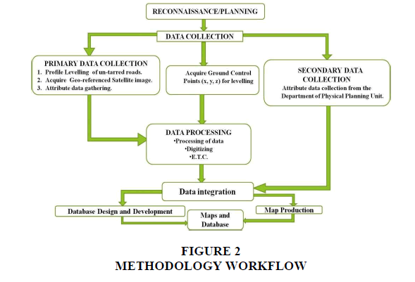
Figure 2 shows the methodology workflow adopted in this study.
Preliminary Investigation/Reconnaissance
The preliminary office planning and reconnaissance survey was carried out during the execution of this project. This was done to acquire necessary information about the study area for proper and efficient execution of the project.
The office planning was carried out in other to find out existing information about the study area. While carrying out this planning, the Geo-referenced Satellite Imagery of the study area was obtained, attribute data of the road network was acquired from Physical Planning Unit of the Campus and Coordinates of Ground Control Points (GCPs) of the study area were also obtained from the Department of Geoinformatics and Surveying.
The field reconnaissance revealed the extent and topography of the study area. The Table 1 shows the list of controls points used for the profile leveling of the un-tarred roads within the study area.
| Table 1 List Of Controls |
||||
|---|---|---|---|---|
| S/No | Control ID | Easting (m) | Northing (m) | Height (m) |
| 1 | KIN 09 | 334487.648 | 710277.506 | 232.459 |
| 2 | DPR772/773_3 | 334898.858 | 710121.708 | 232.931 |
| 3 | KIN 07 | 334775.455 | 710238.925 | 233.203 |
Data Acquisition
The acquired data can be categorized into primary and secondary data. Primary sources include; Profile leveling of the un-tarred roads using the leveling instrument at 25m chain age interval, Geo-referenced Satellite Imagery, visible attributes of the road, etc. Secondary sources on the other hand include; Coordinates of GCPs (x, y, z), and attribute data collection from the Department of Physical Planning Unit.
Data Processing
The Spot Heights obtained for the road profiling were reduced and the Elevations of the intervals obtained. The observed data was recorded in the field book with the following headings: Chainage, Back Sight, Intermediate Sight, Fore Sight, Height of Instrument, Reduced Level and Remark. Necessary computations and error distribution were carried out. During the computation, the reduced level was corrected using the following formula:
(Final Reduced Level of BM – Initial Reduced Level of BM) ÷ No. of Change Points
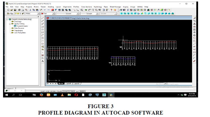
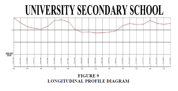
The dividend gotten from the formula above was multiplied by consecutive number of change points, ranging from the first to the last change point in the other of 1, 2, 3… as the case may be. The product of each change point and the dividend was applied to all the observations made from particular change points respectively. Corrections were applied in the opposite direction of which errors occur. The reduced level and chainage of the profile were typed and saved in Notepad. The file was used to produce the profile diagram in AutoCAD Land Development as shown in Figure 3.
Satellite Imagery Processing
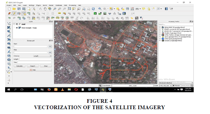
The Geo-referenced Satellite Imagery was vectorized. Vectorization also known as Digitizing is the process of extracting vectors from raster data. This was done in order to extract the road networks from the imagery using QGIS software as shown in Figure 4.
Data Integration
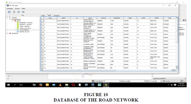
Data integration as used in this study refers to data compilation. This process refers to bringing together all the data collected for this project from various sources. This is one of the inevitable tasks in digital mapping and was achieved by adding all the data gotten from both primary and secondary source into the attribute table of QGIS. The attribute table contains well-defined information about the road. In addition to the spatial attribute data, Images of the longitudinal profile diagrams plotted in AutoCAD Land Development were added to the un-tarred road as an added attribute to the map using the Action option of QGIS. This is known as hyperlinking, with the Action Option, one can add a lot of extra functionality to a map, allowing users to retrieve additional features and information about an object. The functionalities of PostgreSQL and PostGIS were explored in this project. Database can be designed as standalone in a database management engine like the PostgreSQL and SDE. It can also be developed to be used in software like QGIS and other GIS software while using the PostGIS as the link. In this project, PostgreSQL was used to develop a database which was later linked to PostGIS in other to access the database through QGIS. Maps are the major products of this project. The longitudinal profile PDF map was produced and the road network map was also produced (Obafemi et al., 2011).
Analysis and Result
Analysis
At the end of the database design and development, some analysis was performed in QGIS software to ascertain the correctness of the work and to be sure that the output was in line with the aim. Three methods were used to achieve this.
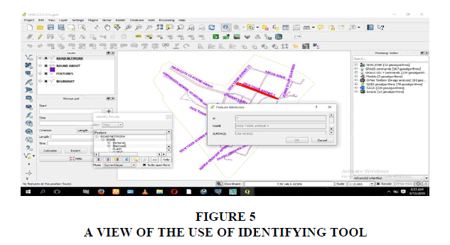
Identify Tool
The identify tool is an interactive tool which allows user to interact with the map canvas and get information on desired feature in a pop-up window. This tool was used during the analysis of this work, once clicked information about the desired road was displayed (Figure 5).
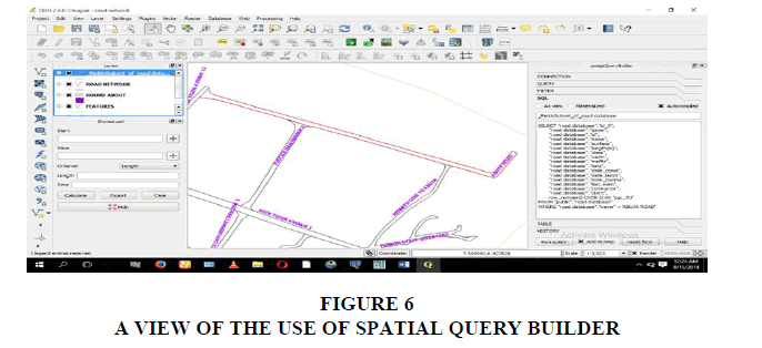
PostgreSQL Query Builder
This is a plugin in QGIS software which can be used to perform query. In this study, the road name Abuja was queried and the result showed the road named Abuja in a red color (Figure 6).
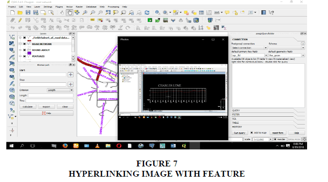
Run Feature Action Tool
Using the Run Feature Action tool, the hyperlinked images of the road appears when any un-tarred road is clicked (Figure 7).
Results
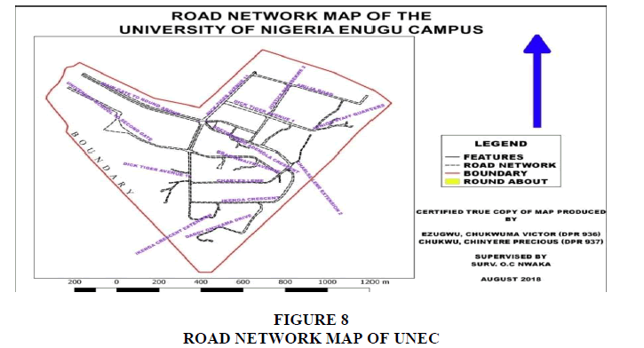
The results of this study includes: Map of the road network, Map of profile diagrams of the un-tarred roads and Database of the road network. Some of the excerpts from the results of this project are shown in Figures 8-10.
Conclusion
The efficiency of GIS in road network analysis is evident in this study. The general purpose of this project which was to produce a map and database that would serve as a tool for road networks in the University of Nigeria, Enugu Campus, and this was achieved by the results of this study. The aim of this study was achieved through primary and secondary data acquisition, data processing, data integration, database design &development and map production. Hence, the problems of lack of up-to-date database/information of road networks within the University of Nigeria, Enugu Campus have been solved through the successful completion of this study.
Following the successful completion of this study, it was observed that more work needs to be done. Thus, the following recommendations are made:
• This study can be carried out on a larger scale and other attributes such as the drainage system, vehicular movement, Road maintenance due date, may be included among other things.
• This project focused on desktop interface, Web interface for such kind of project is recommended.
• The open source software used in this project i.e. QGIS and PostgreSQL has more functionality which can be used to expand the scope of this Study.
• It is also recommended that this project be reviewed and the database updated from time to time. These will help to provide up to date information on all the roads within the campus which will aid in decision making for the maintenance and management of the roads.
References
Abah, E.J. (2016). Digital Mapping of Surface and Underground Utilities in the University of Nigeria, Enugu Campus, A B.sc Degree Project, DPR 887. Unpublished Undergraduate Project Department of Geoinformatics and Surveying University of Nigeria Enugu Campus.
Acquah, P.C., & Fosu, C., (2017). Implementation of Geographic Information System Application in the Maintenance Management of Roads in Ghana: A Case study of Roads in Kumasi Metropolis. American journal of Geographic Information System, 6(3) 90-102.
Amina, D., & Ajie, E., (2014). A GIS Based Road Network of Port Harcourt, Nigeria. FIG Congress 2014, Engaging the challenges - Enhancing the Relevance Kuala Lumpur, Malaysia 16-21.
Idhoko, K.E., Aguba, W., Emefeke U., & Nwanguma, C., (2015). Development of Geographic information systems Road Network Database for Emergency Response: A case study of Oyo town, Oyo state, Nigeria. International Journal of Engineering Science Invention 4(12), 34-42.
Idhoko, K.E., Ndiwari, E.L., Ogeh, V.C., & Ikegbulam, S.C., (2016). Urban road network analysis of Yenagoa, Bayelsa State Using GIS. International Journal of Engineering and Computer Science ISSN: 2319-7242, 5(1), 15605-15615.
Irfan, A.M., (2005). Application of GIS in transportation for road network analysis. Faculty of Civil Engineering, Universiti Teknologi, Malasia.
Kayondo-Ndandiko, L. M. (2011). Geographical Information Technologies for Road Infrastructure Maintenance in Uganda. Doctoral dissertation, Blekinge Institute of Technology.
Ndiwari, E.L. (2014). Road network Analysis for Yenagoa Local government Area, Bayelsa State. Unpublished thesis, Federal School of Surveying Oyo, Oyo State 1-3.
Obafemi, A.A., Eludoyin, O.S., & Opara, D.R. (2011). Road Network Assessment In Trans-Amadi, Portharcourt In Nigeria Using GIS. International Journal for Traffic and Transport Engineering, 1(4), 257-264.
Omunguye, A. (2004). Digital Mapping of Road Network Systems in Port Harcourt. A project submitted in partial fulfillment of requirements of Rivers State University for the degree of Bachelor of Technology: Rivers State University of Science and Technology: PortHarcourt.
Received: 17-Jan-2022, Manuscript No. jmids-22-10962; Editor assigned: 19-Jan-2022, PreQC No. jmids-22-10962(PQ); Reviewed: 24-Jan-2022, QC No. jmids-22-10962; Revised: 27-Jan-2022, Manuscript No. jmids-22-10962(R); Published: 31-Jan-2022
